

- Posted on 30 Jan 2021
- Updated on 30 Jan 2021
- 3-minute read
An innovative digital tool allows community members to take an active role in planning urban green space.

Village Vanguard is a workshop and survey tool that helps urban planners, decision-makers and community organisations engage the public in green space planning. Increasing green spaces makes cities more resilient to climate change, and community participation in their planning increases their success and improves urban governance. However, community collaboration processes can be costly to run, report and replicate.
Village Vanguard sets out to make these processes less resource intensive by combining open source mapping software (Mapseed.org) with publicly available geo-spatial data and a simple web survey. The goal is to provide a workshop tool for face-to-face deliberation and idea generation that is easy to set up, replicate and share.

Geo-spatial data sets are used to inform, capture and share community ideas on the parks and green corridors in their city. These data sets are visualised and layered onto an interactive map, and may include: public transport, bike lanes, land use zoning, population density and demographics, heat maps and flood zones. Community comments are captured and categorised in a simple web survey, accessed via a map layer or comment explorer, that can be easily analysed and shared.
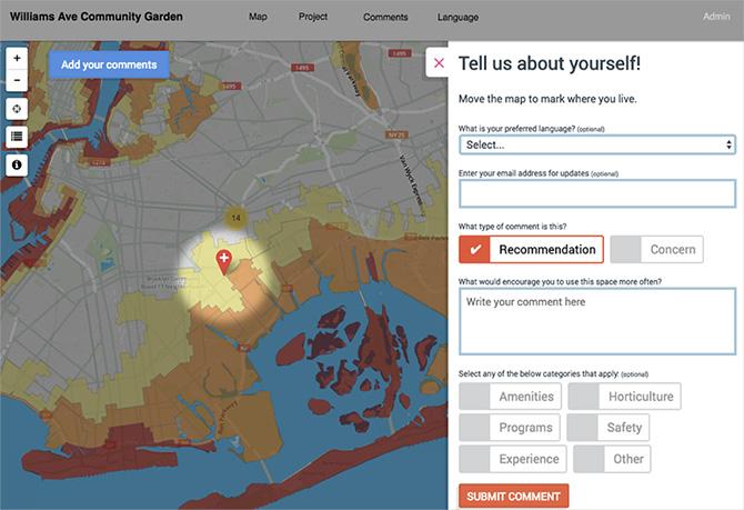
By informing community discussion, Village Vanguard educates participants on the environmental, social and political considerations of urban green space planning. Along with geo-spatial data, the application also provides information on the organisations and government bodies involved in the green space project, as well as timelines, project phases and design documentation.
The first iteration of Village Vanguard was built at the Collective Intelligence for Democracy workshop run by the City of Madrid’s MediaLab-Prado in November 2017, and was designed in collaboration with the New York Restoration Project.
This research is the work of ISF PhD candidate Erika Whillas. Erika is currently undertaking a PhD at the Institute for Sustainable Futures, UTS, researching how to use technology to assist community engagement in urban green space planning. The goal of this project is to develop an open source collaboration tool to assist the preparing, running and reporting of community engagement workshops that inform urban green space policy and projects.
Erika has worked as an Information Architect and UX designer for 15 years, and is Cofounder and Chief Product Officer of CoClear, a New York consultancy that specialises in fast life cycle analysis of consumer products. The CoClear application correlates financial and environmental metrics in data visualisations and product reports, to help companies reduce greenhouse gas emissions while maintaining profitability.
- Erika Whillas
Study
