

- Posted on 19 Apr 2024
- 6-minute read
Intense rain and flash floods have increased inland in eastern Australia write Milton Speer and Lance M Leslie.
Before climate change really got going, eastern Australia’s flash floods tended to concentrate on our coastal regions, east of the Great Dividing Range.
But that’s changing. Now we get flash floods much further inland, such as Broken Hill in 2012 and 2022 and Cobar, Bourke and Nyngan in 2022. Flash floods are those beginning between one and six hours after rainfall, while riverine floods take longer to build.
Why? Global warming is amplifying the climate drivers affecting where flash floods occur and how often. All around the world, we’re seeing intense dumps of rain in a short period, triggering flooding – just as we saw in Dubai this week.
Our research shows east coast lows – intense low pressure systems carrying huge volumes of water – are developing further out to sea, both southward and eastward.
This means these systems, which usually bring most of the east coast’s rain during cooler months, are now dumping more rain out at sea. Instead, we’re seeing warm, moist air pushed down from the Coral Sea, leading to thunderstorms and floods much further inland.
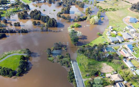
This month, a coastal trough along the Queensland and New South Wales coasts and an inland trough resulted in unusually widespread flooding, triggering flooding in Sydney as well as inland.
What’s changing?
On the coasts, extreme flash floods come from short, intense rains on saturated catchments. Think of the devastating floods hitting Lismore in 2022 and Grantham in 2011.
Inland, flash floods occur when intense rain hits small urban catchments, runs off roads and concrete, and flows into low-lying areas.
The April flooding in NSW and Queensland had elements of both. Early this month, the subtropical jet stream changed its course, triggering a cyclonic circulation higher in the atmosphere over inland eastern Australia.
At the same time, a low-pressure trough developed low down in the atmosphere off the coast and another inland, through southern Queensland and NSW, where they encountered warm moist air dragged by northeast winds from as far away as the Coral Sea.
The result was localised extremely heavy rain, which led to the Warragamba Dam spilling and flood plain inundation in western Sydney.
This unusual event has been referred to as a “black nor’easter”, a term coined in 1911. These are characterised by a deepening coastal trough and upper-level low pressure systems further west, over inland eastern Australia. This term, mostly known in the marine fraternity, became less common during the 20th century. But it has returned.
Why? Global warming is changing how the atmosphere circulates. As ocean temperatures keep rising, the pool of warm water in the Coral and Tasman Seas grows. This gives rise to northeasterly airstreams, which funnel thick fronts of warm, moist air down towards inland Queensland and NSW.
These low pressure systems occur higher in the atmosphere, causing unstable conditions suiting the formation of thunderstorms. And because these systems move slowly, heavy rain can fall continuously over the same area for several hours. All up, it’s a perfect recipe for flash flooding.
We saw similar systems producing flash flooding in Sydney’s Nepean and Hawkesbury rivers during November and December last year, as well as in other regions of inland eastern Australia.
Is this new? Yes. Between 1957 and 1990, flash floods struck Sydney 94 times. But during this period, fast cyclonic airflow in the upper atmosphere was not connected to the jet stream. Instead, flash floods occurred when slow-moving upper-level low pressure circulations encountered air masses laden with moisture evaporating off the oceans. However, there wasn’t enough water in the air over the inland to trigger flash flooding.
In every case between 1957 to 1990, flash floods in Sydney were not linked to slower-forming riverine floods on the Nepean-Hawkesbury River system. When these rivers did flood during that period, they came from longer duration, less intense rain falling in the catchments, and largely from east coast lows. Now we’re seeing something new.
Haven’t there always been flash floods?
Flash floods are not new. What is new is where they are occurring. These sudden floods can now form well west of the Great Dividing Range.
Previously, inland floods tended to come after long periods of widespread rain saturated large river catchments. Inland flash floods were not so common and powerful as in recent decades.
In earlier decades, inland riverine floods during extreme rainfall years occurred when the fast-moving jet stream high in the atmosphere was further north. This occurred frequently in the cooler months, with long, broad cloud bands blown by or associated with the jet stream producing widespread rain inland. Known as the “autumn break”, it often primed agricultural land for winter crops.
In recent years, these crucial air currents have begun moving polewards.
Now that it’s moving south, we have increasingly warm air over inland eastern Australia which can hold more moisture and result in heavy falls, even in the cooler months.
What about the famous inland floods which move through Queensland’s Channel Country and fill Kati Thanda/Lake Eyre?
These are slow moving riverine floods, not flash floods. Flash floods are often limited to local regions. By contrast, Channel Country floods stem from heavy monsoonal rains from November to April.

Queensland’s Channel Country is a braided landscape which periodically floods. Ecopix/Shutterstock
Short, intense rain bursts are going global
The pattern we’re seeing – more flash floods in unusual places – is not just happening in Australia. Inland areas – including deserts – are now more likely to see flash floods.
Dubai this week had a year’s rain (152 mm) in a single day, which triggered flash floods and caused widespread disruption of air travel. Other parts of the United Arab Emirates got even more rain, with up to 250 mm. In Western Australia’s remote southern reaches, the isolated community of Rawlinna recently had 155 mm of rain in a day.
This is precisely what we would expect as the world heats up. Hotter air can hold about 7% more water for every degree of warming, supercharging normal storms. And these floods can be followed by extended periods of almost no rain. The future is shaping up as one of flash floods and flash droughts.
Milton Speer, Visiting Fellow, School of Mathematical and Physical Sciences, University of Technology Sydney and Lance M Leslie, Professor, School of Mathematical And Physical Sciences, University of Technology Sydney
This article is republished from The Conversation under a Creative Commons license. Read the original article.