The way Sydney feeds itself into the future is being reassessed after an innovative mapping project revealed how small-scale local growers are losing out to urban developers and the big food chains.
From Moore Park to Castle Hill, Sydney gives the impression of being awash with farmers’ markets selling artisanal and locally grown produce to a large and hungry base of customers. But these weekend rituals are misleading.
Local food production in the Sydney Basin is in sharp decline and the farmers who grow and supply Sydneysiders with fresh produce are being squeezed out by urban expansion that prioritises houses and roads over agricultural land.
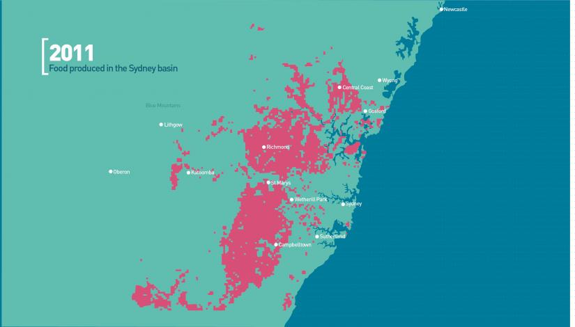
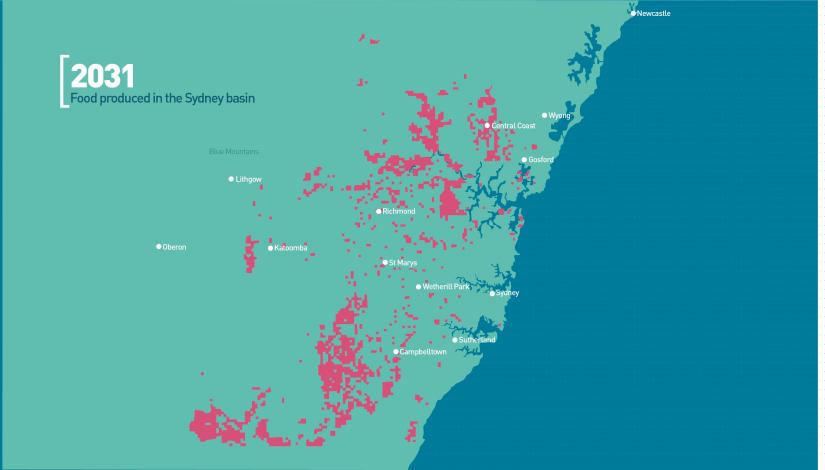
ISF modelling estimated that by 2031 Sydney could have lost about 60 per cent of its total food production and a staggering 90 per cent of local vegetable production, particularly on the outskirts to the south-west and north-west that have been earmarked for development.
But this is far from inevitable. Sydney’s Food Futures, a research study undertaken by the Institute for Sustainable Futures (ISF), in collaboration with government and industry partners, explores the Sydney Basin’s capacity to feed itself and the hidden benefits local agriculture provides to city dwellers.
COVID-19 and bushfires have really highlighted the importance of ensuring sufficient food supply close to where we live.
— Dana Cordell, Institute for Sustainable Futures
Associate Professor Dana Cordell, Research Director at ISF, says balancing housing with food production, environmental protection and population health isn’t simply the best option, it’s essential to ensuring Sydney is sustainable.
“COVID-19 and bushfires have really highlighted the importance of ensuring sufficient food supply close to where we live – in terms of access, diversity, transport and storage of fresh foods,” Cordell says.
ISF’s research shows that residents are increasingly reliant on food grown some distance away and then distributed and transported to where they live.
As Cordell points out, the problem with this trend is that not only can access to food be disrupted during times of crisis, the dramatic loss of agricultural land in the Sydney Basin also presents serious risks to the resilience of the city, the health of residents and the viability of farmers’ operations.
Mapping the future
Understanding the factors that threaten Sydney’s ability to feed itself will be crucial in the face of a growing population. It’s estimated the city will need to provide for 1.6 million new residents by 2031.
In response to that challenge, ISF researchers produced a series of interactive maps modelling four future food scenarios for the Greater Sydney area. These range from the current trajectory of unchecked urban sprawl, urban growth limited to existing urban land and lower quality agricultural land, urban growth on non-agricultural land only, and a hypothetical where food productivity on current agricultural land is maximised.
The implications for food security were analysed in each case along with opportunities for expanding the growth of perishable goods close to market.
Adopting a sustainable local food approach makes Sydney more resilient to change, Cordell says. “It reduces food miles, acts as a buffer against fuel price rises and provides local employment for farmers and food processors, among other advantages.”
Planning in the mix
In Melbourne, currently 40 per cent of the food supply comes from locally grown produce, but ISF’s study found that in 2011 the Sydney Basin produced only half that fraction for Sydney.
For food-obsessed Sydneysiders, statistics like that hit a nerve. When the interactive maps were made public online and on social media, along with an animation and infographics, the research became front-page news in the weekend newspaper the Sun-Herald. A public forum, part of the Sydney Festival, was devoted to the pressures facing agriculture in the Sydney Basin.
The research deliberately coincided with policy dialogues happening at a state level about developing a strategic metropolitan plan to grow Sydney. The maps were seen as useful tools and led to a high-level state briefing with decision-makers.
Feedback from public forums and workshops with key stakeholders have supported the view that the maps are valuable for improved decision-making that takes account of local needs.
Site-based decisions often affect small-scale growers, says Cordell. “The loss of peri-urban agriculture tends to happen on a micro scale – a community garden here, a small-scale commercial family farm there – tiny little pockets disappear and it often goes under the radar.”
Some regions, especially parts of Western Sydney, are already 'food deserts', leaving communities without access to outlets for affordable, fresh and healthy food, leading to poor health outcomes.
Planting a seed
Engaging planners and the public about the origins of their food has been crucial to the study. Advocates for changing environmental policy to a more sustainable model were quick to seize on the maps and scenarios as tools for empowering, educating and enabling consumer voices.
Sharing their vision for what a resilient food future for Sydney would look like in an ISF workshop, stakeholders said it included improved food system literacy, knowing where food comes from (through labelling), planners and decision-makers understanding the significant value of protecting agricultural lands, understanding the resources required to produce food, the waste generated and the health implications for consumers.
As the impacts of climate change become clearer each year, the benefits of peri-urban farming grow more obvious. Growing high-value produce in fertile areas where rainfall is more reliable, and close to market, seems like a no-brainer or, at the very least, food for thought.
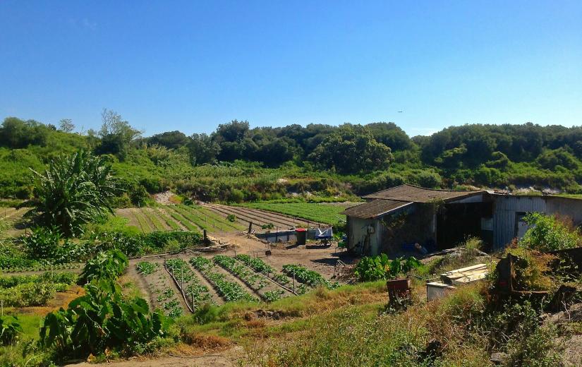
La Perouse Market Garden
Researchers
-
 Research Director
PROJECT | 2014-2016
Mapping Sydney’s Food Sheds
In order to understand how Sydney feeds itself, both now and into the future, we are investigating the Sydney Basin’s capacity to produce food – and to understand the factors that threaten to reduce this ability. Sydney’s Food Futures (2015-2016) is a collaborative research project being undertaken by the Institute for Sustainable Futures at the University of Technology Sydney, in conjunction with a number of government and industry partners.